3.1 热力景观格局变化分析
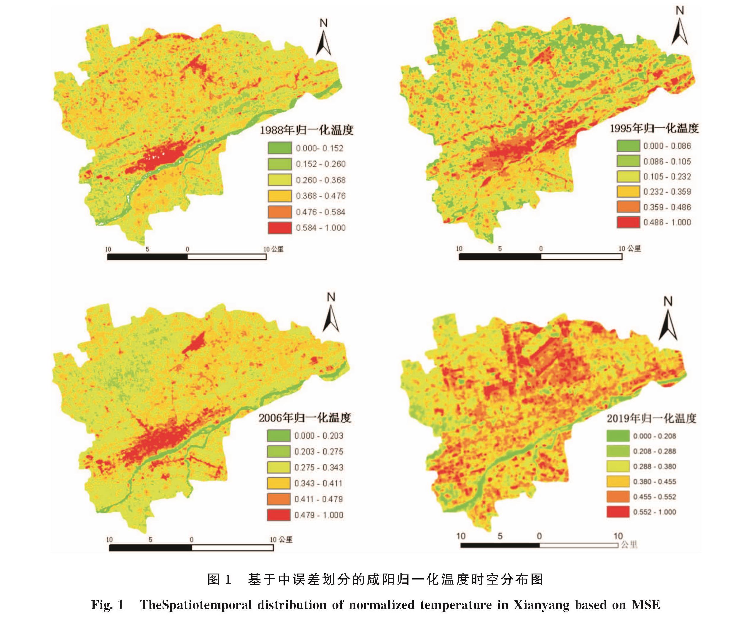
基于上述得到的咸阳市1988、1995、2006和2019年温度数据.运用Vector Utilities模块,将影像由Raster转换为Vector格式,并在ArcGIS10.5平台下,经归一化处理后分别得到不同时相的热环境数据,结果见表2.
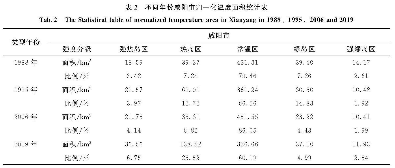
由表2可知:1988年常温区面积为431.31 km2,占咸阳市总面积的79.75%; 热岛区和强热岛区面积为57.86 km2,占总面积的10.66%; 绿岛区和强绿岛区面积为51.97 km2,占总面积的9.87%,由此可见1988年咸阳市常温区占主导地位,其次为热岛区域,最后为绿岛区
表2 不同年份咸阳市归一化温度面积统计表
Tab.2 The Statistical table of normalized temperature area in Xianyang in 1988、1995、2006 and 2019
域.1995年常温区面积为361.24 km2,占咸阳市总面积的66.56%; 热岛区和强热岛区面积为90.58 km2,占总面积的16.69%; 绿岛区和强绿岛区面积为90.92 km2,占总面积的16.75%,表明1995年咸阳市常温区继续占主导地位,其次为热岛区域,最后为绿岛区域.2006年常温区面积为451.55 km2,占咸阳市总面积的86.05%; 热岛区和强热岛区面积为 57.56 km2,占总面积的10.96%; 绿岛区和强绿岛区面积为33.65 km2,占总面积的6.42%,表明2006年咸阳市常温区继续占主导地位,且面积显著较1995年增加,其次为热岛区,最后为绿岛区.2019年常温区面积为326.66 km2,占咸阳市总面积的60.19%; 热岛区和强热岛区面积为175.18 km2,占总面积的32.27%; 绿岛区和强绿岛区面积为39.03 km2,占总面积的7.53%,由此表明尽管2019年咸阳市常温区继续占主导地位,但热区域显著增加,常温区减少面积主要流向了热区域; 同时,绿区域较2006年表现为微小幅度增加的趋势.由此可见,1988~2019年间咸阳市始终常温区占主导地位,且2006年占比最大为86.05%,2019年占比最小为60.19%; 热区域面积次之,且2019年占比最大为32.27%.综合分析:1988~2019年31年间热区域变化幅度不大,绿区域占总面积最小,但整体呈现下降的趋势.
3.2 热力景观数量变化分析
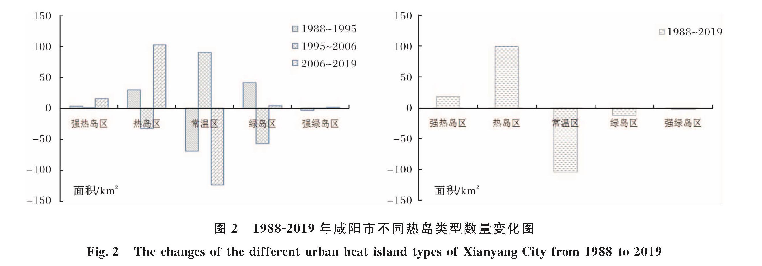
为了进一步剖析1988~2019年咸阳市热力景观的变化情况,以1988、1995、2006和2019年为时间节点分别计算咸阳市不同热力斑块的变化情况(图3).结合图3和表2可知:1988~1995年,咸阳市常温区和强绿岛区面积持续减少,且常温区面积减幅最大,累计减少70.07 km2,年均减少10.01 km2.绿岛区、热岛区和强热岛区面积均增加,其中绿岛区面积累计增加41.1 km2,年均增加5.88 km2; 强热岛区面积增幅最小,累计增加2.98 km2.通过转移矩阵分析发现:常温区减少的面积主要流向绿岛区和热岛区,强热岛区面积的增加主要源自于热岛区域.1995~2006年,常温区和强热岛区面积持续增加,其中常温区增幅最为显著,累计增加90.31 km2,年均增加10.03 km2.同时,热岛区、绿岛区和强绿岛区均表现为减少的趋势; 热岛区和绿岛区面积减幅显著,9年间热岛区和绿岛区累计减少33.2 km2和57.28 km2,强绿岛区面积基本保持不变.通过转移矩阵分析发现,减少的热岛区和绿岛区均流入常温区.因此,2006年咸阳市整体热环境较1995年呈现恶化的趋势.2006~2019年,除了常温区面积急剧减少外,强热岛区、热岛区、绿岛区和强绿岛区均表现为面积增加的趋势,且热岛区增幅最为显著,13年间累计增加102.71 km2,其次为强热岛区域,累计增加14.91 km2,绿岛区和强绿岛区变幅最小,累计增加面积3.88 km2和1.52 km2.综合分析1988~2019年31年间咸阳市不同热力景观面积变化特征,发现31年间热岛区域显著增加,累计增幅99.25 km2,强热岛区增加18.07 km2; 同时,常温区减幅最为显著,31年间累计减少104.65 km2,变化比占咸阳市总面积的19.28%.进一步分析发现,咸阳市31年间热环境整体表现为加剧的趋势,同时,局部热环境恶化显著.
3.3 热力景观格局演变分析
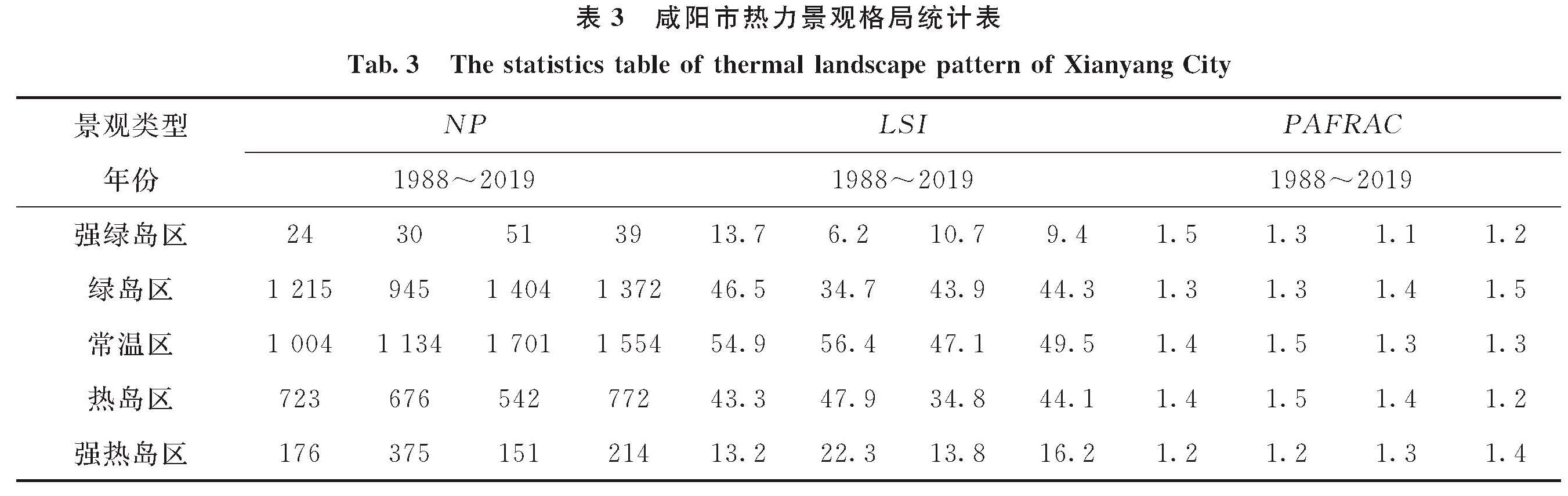
景观格局既是景观异质性的体现,又是人类活动与各种生态过程在不同尺度上综合作用的结果.城镇热环境景观是城镇与周围环境相互作用而形成的,是人工干预城镇局地生态系统导致局地气候变异的热力学表现[15].本文从斑块、类型和景观三个层次择斑块总数(NP)、景观形状指数(LSI)、周长-面积分维数(PAFRAC)和聚集度指数(CONTAG)4个指标[16]用以分析咸阳市1988~2019年31年间热力景观格局的演变特征.基于ENVI5.2平台,采用中误差划分的方法将研究区热力景观类型划分为五大类,利用ARCGIS10.5平台将分类后数据转化为ARCGRID格式,最后利用景观分析软件FRAGSTATS4.2分别计算了不同时相反演结果的景观指数(表3,表4).
图2 1988-2019年咸阳市不同热岛类型数量变化图
Fig.2 The changes of the different urban heat island types of Xianyang City from 1988 to 2019
表3 咸阳市热力景观格局统计表
Tab.3 The statistics table of thermal landscape pattern of Xianyang City
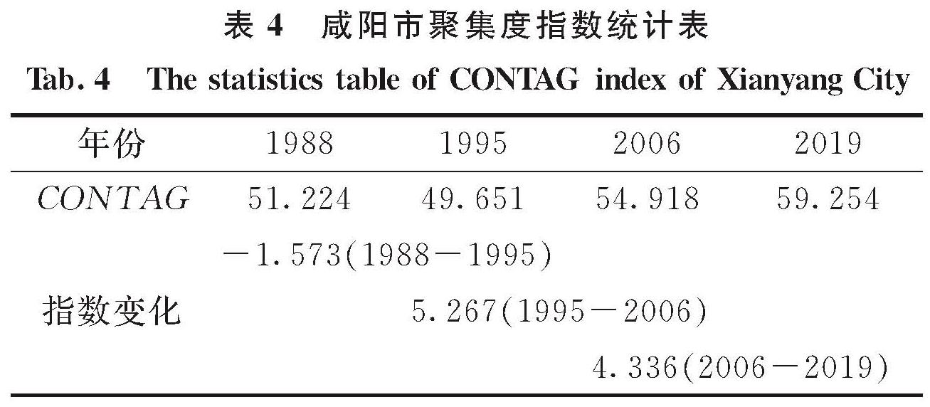
表4 咸阳市聚集度指数统计表
Tab.4 The statistics table of CONTAG index of Xianyang City
NP指数变化分析:咸阳市强绿岛区斑块数1988~1995年呈现小幅增加的趋势,1995~2006年呈现较大幅度增加的趋势,11年间斑块数累计增加21个; 2006~2019年,强绿岛区NP个数呈现减少的趋势,13年间累计减少12个.分别提取强绿岛区并利用ArcGIS空间叠加分析功能,对比分析1988年和1995年NP变化发现,该时间段增加的强绿岛斑块主要集中在渭河沿岸地区.绿岛区斑块数1988~1995年呈现减少的趋势,7年累计减少270个.1995年之后呈现较大幅度增加的趋势,截至2006年,绿岛区斑块数较1995年增加459个,2019年绿岛斑块数较2006年呈现小幅度减少的趋势,13年间累计减少32个.分析原因主要是由于城市的快速发展,使得具有高吸热的建设用地取代自然地表覆盖所致.常温区2006~2019年13年间,NP指数呈现先增加后减少的趋势,1988~2006年,该时间段常温区NP指数增加明显,累计增加斑块697个,主要是由于土地利用方式的改变所致,通过空间叠加对比发现,变化最为剧烈的区域主要集中在城市周边地区.2006年之后,常温区斑块数表现为减少的趋势,13年间累计减少147,分析原因在于耕地等较低热熔的土壤覆被类型被水泥、沥青等高吸热材料代替所致.热岛区斑块指数呈现先持续减少,后较大幅度增加的趋势,且变化的区域主要集中在咸阳市的东北方向.同时相比1988年,高温区变化主要呈现基于原热区域的片状扩展与延伸.强热岛斑块呈现先增加后持续减少的趋势,1988~1995年累计增加199个,之后截止到2006年,NP指数累计减少124,之后表现为增加的趋势,13年间累计增加强热岛斑块63个.分析原因在于土地利用类型的转变导致的区域地表热辐射平衡被打破所致.
(2)LSI变化分析:咸阳市强绿岛区景观形状指数1988~1995年7年间持续减少,1995~2006年11年间又急剧增加,之后2006~2019年13年间较小幅度减少.表明强绿岛区斑块形状在城市化的不同阶段整体趋于简单化.绿岛区1988~1995年7年间斑块复杂度总体表现为降低的趋势,累计减少11.8,表明在改革开放不久后的咸阳市该时间段绿岛区景观形状趋于规则化,与当时的农业经济发展模式相一致.1995年后绿岛区景观形状指数呈现持续上升的趋势,至2019年累计增加9.6,表明自1995年后市场经济发展以来,咸阳市绿岛区景观形状伴随经济市场复苏与多元化发展模式,绿岛区斑块逐渐趋于破碎化和复杂化,这与城市在这一时间段开始规模化建设起步相一致.常温区1988~2006年18年间斑块形状指数持续变小,表明常温斑块在这一时期趋于复杂化; 2006年后则呈现规则化特征,前者是因为组成常温地表覆被不断遭遇无序建设与开发的结果,而后者则是城镇化体系及其空间格局基本形成,同时城镇化建设更加注重规划、有序开发的结果.热岛区景观形状指数1988~2019年31年间呈现先小幅增加,后大幅度降低,降幅为13.1,之后又增加的趋势,分析原因在于2002年西咸一体化政策实施后,城市开发强度和速度不断加快,城市地表覆被急剧变化,且已有的城镇空间格局中城镇生态建设中的公园、绿地等低容物质的大量出现,使得城镇热岛区域形状复杂度降低后又增大的趋势.热岛区景观形状复杂度指数呈现先升高,后降低又持续走高的趋势.分析原因一方面是由于城市组团类型建筑在2000年后不断涌现,另一方面城市开发强度、空间和格局更加紧凑的结果.
(3)PAFRAC变化分析: 31年间咸阳市强绿岛区斑块分维数呈现小幅降低的趋势,表明强绿岛区的斑块趋于规则化,主要原因是城市进一步开发建设使得城市水体及高密度绿化区呈现单一化、有序化.绿岛区和强热岛区呈现较为相近的变化规律,即先持平后小幅增加.常温区和热岛区则整体表现为小幅增加的趋势,表明改革开放经济快速增长的同时,热斑块复杂度增加,城市土地利用异质性加剧; 2006年后又表现为小幅减少的趋势,表明西咸一体化进程不断加快过程中,咸阳市通过合理的城市规划、增加绿化及水域面积等相关措施使得常温区域斑块趋于规则化.
(4)CONTAG变化分析:咸阳市景观聚集度指数由1988年的51.224减少到1995年的49.651,表明咸阳市7年间土地利用整体趋于复杂化与破碎化,进而导致许多离散小斑块的产生,究其原因是大面积优势斑块被不断扩张的离散型城镇建设用地不断替代和冲击的结果; 到2006年CONTAG指数增加到54.918,较1995年增加了5.267; 至2019年景观聚集度指数则高达59.254.1988~2019年31年间CONTAG指数整体增加8.03,表明咸阳市热环境景观格局趋于整体化,究其原因是咸阳市大规模建设过程相对完成,地表覆被格局已基本形成所致.
3.4 热力景观的空间演变特征分析
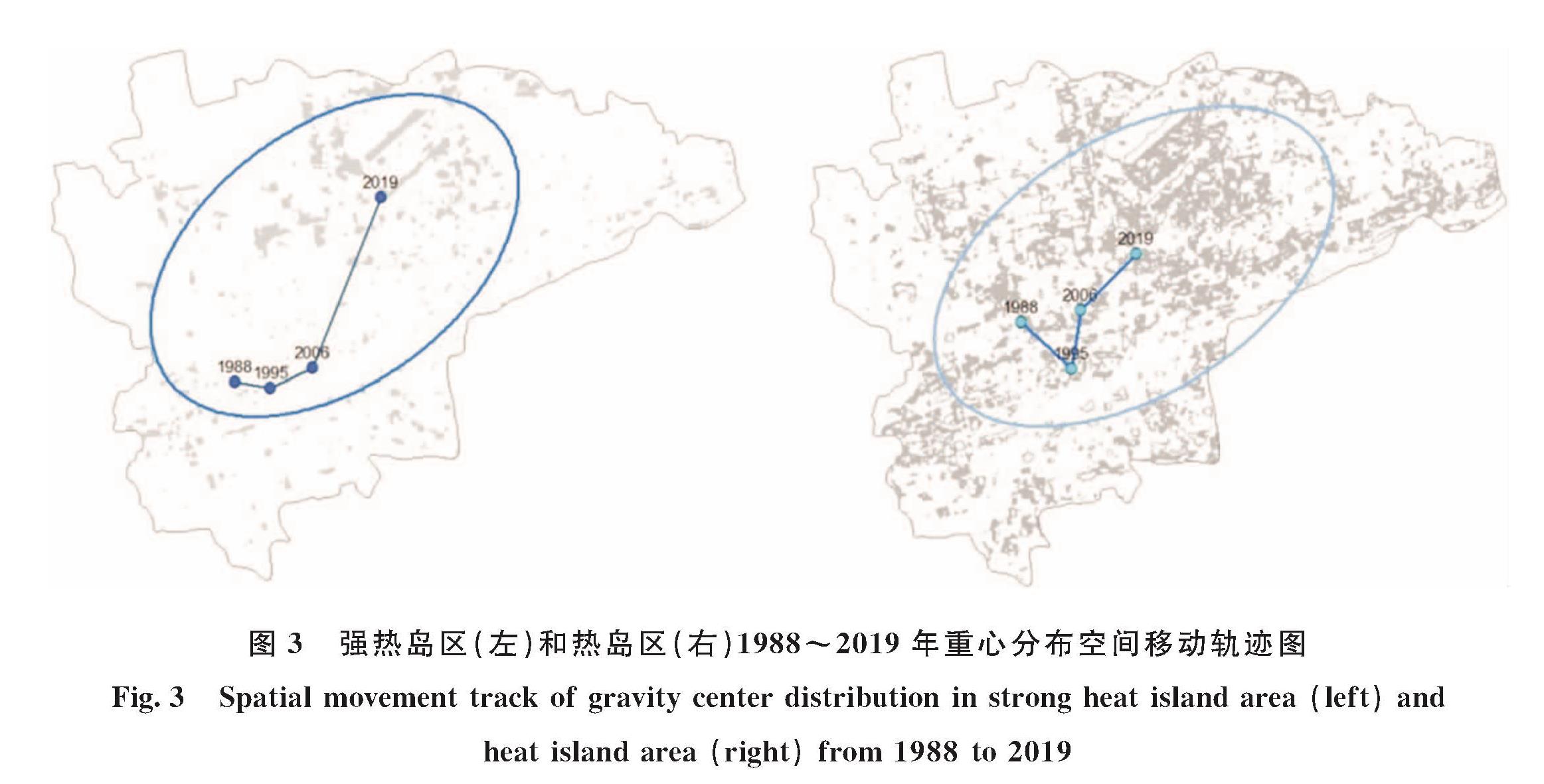
为了进一步剖析不同时间节点,咸阳市强热岛区和热岛区两类热力景观的空间演化过程,基于GIS提供的度量地理分布功能,采用中心要素和利菲弗方向性分布算法,刻画不同时间节点的热环境区域空间位置及伴随时间的推移轨迹,结果见图3所示,用以分析随时间变化和城市不断发展,城市强热岛区和热岛区两类热力景观的空间演变特征.
图3 强热岛区(左)和热岛区(右)1988~2019年重心分布空间移动轨迹图
Fig.3 Spatial movement track of gravity center distribution in strong heat island area(left)and heat island area(right)from 1988 to 2019
由图3可知,1988~1995年7年间强热岛区中心分布呈现由西向东的趋势,之后向咸阳市东北方向偏移,2006~2019年13年间强热岛区中心点位继续向东北方向偏移,且该时间段偏移量最大.结合咸阳市地图可以看出,2019年咸阳市强热岛区的中心点位已经由原咸阳市旧城区开始转向空港新城方向,特别是2010年以后空港新城的高强度开发与建设已经导致该区域成为新的强热岛区域,由于该区域的存在与影响,整体导致咸阳市强热岛区域的空间走向偏向东北方.对于热岛区而言,1988~1995年7年间咸阳市热岛区域中心偏向东南方向,之后偏向北方,2006年以后,热岛区域继续偏向东北方,但增加幅度小于强热岛区,进一步分析发现,强热岛区和热岛区的空间发展方向相一致,但强热岛区比热岛区的发展空间跨度更大,表明在空港附近由原有的低热容的地表覆盖被高热熔的水泥、柏油等下垫面所取代,具有高热容吸热、储热能力强的建筑材料的广泛使用,使得咸阳市强热岛区和热岛区变化显著.以标准差椭圆走势可以看出,无论是强热岛区还是热岛区,它们的宏观走势均由西南方向走向东北方向.且热岛区域在偏向东北方的同时,更多的偏向东方,即西咸一体化所在的西咸新区.由此表明,咸阳市空间热力景观格局随着西咸新区、空港新城等的不断建设与完善,已经形成了新的热力格局.认识和了解咸阳市热力中心的动态演变有利于后期合理规划和制定相应的缓解城市热环境的策略.
![表1 大气平均作用温度与近地面气温关系式(覃志豪,2003)[13]<br/>Tab.1 The relationship between the average temperature of atmosphere and the ground temperature](2021年03期/pic180.jpg)